by Nick Russo, Senior Transportation Planner
The idea of a continuous, connected, low-stress bicycling route through Berkshire County has persisted for decades. Connecting our major town and village centers with a real cycling option would provide an alternative to the notorious congestion and parking crunch in the summer months and would lower the cost of transportation for workers and shoppers.
After getting a unique opportunity to visit continental Europe this summer and cycle over 160 miles around southern Germany and the Netherlands, there were many examples that stood out to me for what could be brought back to the Berkshires. Solutions that we may not have considered as thoroughly up to this point should be worked into the Berkshire Bike Path plan. These include (1) regionwide bicycle wayfinding systems, (2) a reimagining of how the highway right-of-way could be allocated for driving, cycling, and walking, and (3) smart ways of sharing existing streets where appropriate.
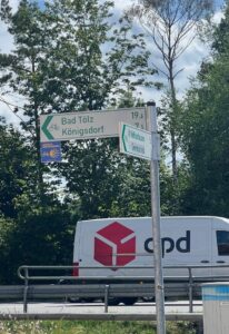

Wayfinding signs in Germany (left) and the Netherlands (right) provided guidance and reassurance while navigating on both rural country roads and dense urban cities.
Navigating around Berkshire County by bike can be different than by car. With e-bikes now a staple offering at most bike shops, the Berkshire Hills need no longer be seen as a barrier for cycling in the region. And trust me, from my experience – climbing a hill with or without an e-bike on a safer, quieter back road or separated bike path just feels easier than hugging the shoulder on a main highway with traffic whizzing past. Navigating the back roads of Berkshire County can be a relatively easy venture with a robust system of wayfinding. In my travels in Europe, nearly every junction along the designated cycling network had a guide sign to keep me going in the right direction.